Dear All,
This third and final exercise will get you familiar with identifying your position (and any other location) using latitude and longitude and measuring distance on maps and in the field.
These are fundamental concepts to understand and read maps and navigate. This exercise is to be completed individually by each member of the team.
This assignment is mandatory to be completed before attending the Navigator Bootcamp workshop.
On your laptop open a browser and open Google Maps, Earth View
Locate your residence in Chennai, right click on the house and choose "What's here?"
The latitude and longitude of your home will be displayed: example below: 12.962163 degrees North, 80.262975 degrees East
Each location on Earth is uniquely identified using a lat + lon
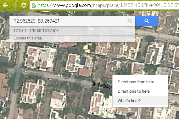
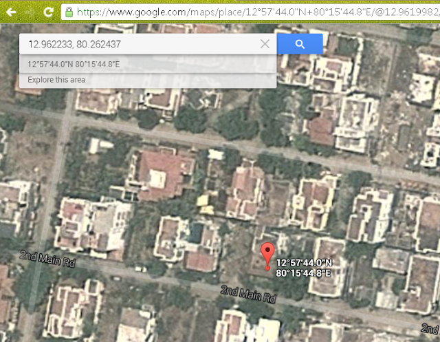
If you click on the shown [lat,lon] Google Maps will automatically convert if from decimal degrees to degrees, minutes and seconds: example:
12°57'44.0"N 80°15'44.8"E
12.962233, 80.262437
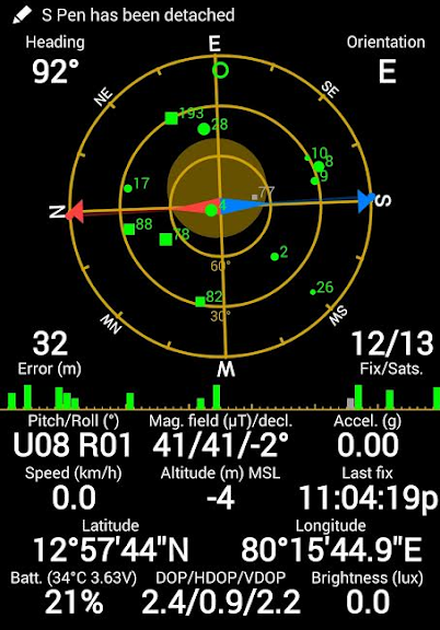
Step outside your home to get a clear view on the sky and switch on the GPS of your Smartphone
Open any GPS app (e.g. "GPS Status") and check your current position (lat, lon)
Verify this matches with the location shown on Google Maps
We now understand how to identify our current position. Next let's learn the basics of latitudes, longitudes and distance
Latitude
Latitude indicates the vertical location above (North) or below (South) the equator. The equator corresponds to 0 degrees latitude.
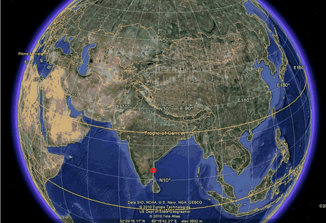
The distance from the equator to the North pole is 90 degrees (horizontal circles shown below every 10 degrees - North 10, 20, 30, 40, 50, etc.)
Chennai is located at a latitude of around 12.5 degrees North of the equator
Longitude
The Earth perimeter (along the equator) is 360 degrees, divided in two sections: 180 degrees East of Greenwich (London) and 180 degrees West
The Greenwich meridian corresponds to 0 degrees longitude (vertical circles shown below cutting connecting both poles, every 10 degrees - East 30, 40, 50, 60, 70, etc.)
Chennai is located at a longitude of around 80 degrees East of Greenwich
Distance
The Earth perimeter is approximately 40000 km which corresponds to 360 degrees
1 nautical (sea) mile equals 1852 meters so the Earth perimeter equals 21598 nautical miles
1 degree corresponds to 21598 / 360 = 60 nautical miles
1 minute = 1/60 degree = 1 nautical mile
1 second = 1/60 minute = 1852 / 60 = 31 meters
Any civilian GPS will show your current location accurately to 0.1 second (3 meters)
Maps
For any map to be useful in navigation it should be geo-referenced
This means it should show be possible to identify the lat/lon of any location on the map
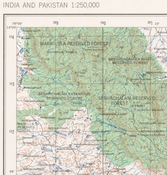
Below map of Venkateswara shows:
* horizontal: longitudes: 79 deg East (top left corner) and 79 deg 15 min East (top right side)
* vertical: latitudes: 14 deg North (top left corner) and 13 deg 45 min North (top left side)
So this map fragment shows 15 by 15 minutes or 15 nautical miles or 27.8 kilometers
if I know my current location (lat, lon) using a GPS then I can pinpoint my approx location on this map
Understanding your current location on a map is the basis for navigation
E.g. this allows you to identify your relative position from any other reference point on the map (peak, valley, rest house, ...)
Assignment
Let's get a hands-on feel of all this by measuring the distance between two points - e.g. between your home (above) and a second landmark in your neighborhood (house, street, etc.). Example: I marked a street corner East of my home at location:
12°57'45.1"N 80°15'37.5"E
12.962520, 80.260421
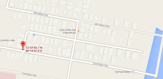
My home was located at:
12°57'44.0"N 80°15'44.8"E
12.962233, 80.262437
Distance between both points is:
1.1 seconds North (latitude)
7.3 seconds East (longitude)
If we ignore the small shift in latitude and just calculate 7.3 seconds longitude x 30.9 meters per sec = 225 meters
Now, verify whether this is correct by walking from your home to the second landmark in your neighborhood with your Smartphone GPS app tracking the distance:
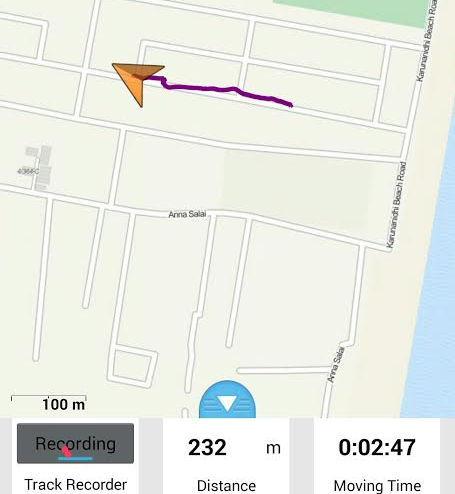
We see that we get nearly the same distance (7 meters error as I met a CTCian along the way and turned back :-) measured on the ground as indicated on the map
Finally open any GPS app on your smartphone to read the lat and lon at the second landmark in your neighborhood:
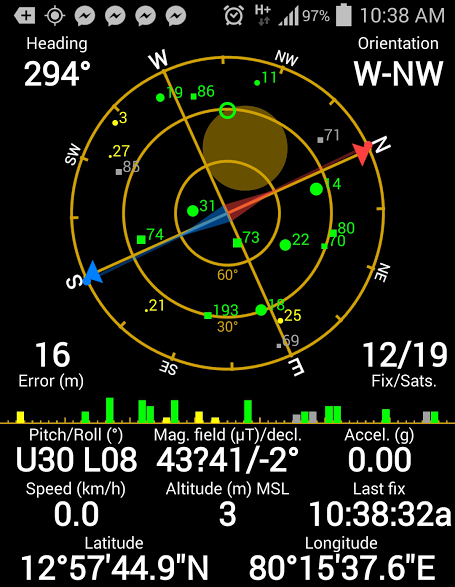
This once again matches with the lat/lon indicated on Google Maps above:
12°57'45.1"N 80°15'37.5"E
12.962520, 80.260421
Congratulations ! You have learned to identify any location using latitude and longitude both on map and in the field and to measure distance.
You are now ready for the Navigator Bootcamp!
Deliverables to the organizer to complete this exercise: (for each team member) screenshot of Smartphone Map App showing two landmarks, location of both (lat, lon) and the distance measured between both (calculated on map and measured with GPS).

0 comments:
Post a Comment